Reliability is the most important feature of any floating Lidar system and is a core tenet of Blue Aspirations’ design philosophy. Drawing on our team’s expertise in design principles from the telecommunications industry, the system emphasizes redundancy in its key components. The commercial model was also iteratively designed using simulations to model failure paths and eliminate single point of failures. Key examples of how these principles are embodied in the floating Lidar system include:
Since the motion of the buoy affects LiDAR wind direction and wind speed measurements, Blue Aspirations’ system is equipped with a motion sensor to acquire high-resolution pitch and roll data, and heading and DGPS sensors to obtain accurate heading information. Our patented algorithm then uses a projection method to correct the LiDAR wind speed data to the appropriate horizontal plane. By calculating the LiDAR installation angle offset from the heading sensor’s true north, the system is likewise able to transform the collected wind direction data to the correct angle.
Modules | Details |
Buoy |
-Diameter: 5m -Height: 9m -Weight: 14.5t -Net Buoyancy: 10.5t -Structure: multiple cabinets -Materials: PE, carbon steel, stainless steel |
Mooring System |
-Water-depth: >5m -Anchor: cement block and/or mooring anchor -Mooring: one-point mooring -Adjustable to suit site-specific requirements including deep water-depth -Multiple mooring system is also available |
Control System |
-Industrial PLC -or BA's embedded controller |
LiDARs |
-LiDARs: Dual LiDAR(default) (Windcube offshore version; ZX 300M, Movelaser B300M) |
Power Supply |
-Battery Capacity: total 60kwh in multiple groups; -Wind Turbines: 2×350W; -Solar Panels: 1600W, multiple groups; - Fuel cells: 2x110W with 224L fuel(optional) |
Navigation System |
-AIS×1 -Radar reflector×2 -IALA compliant navigation ligh1×-1 Supporting dual navigation ligh but n Need to meet the requirement of local authority |
Positioning System |
-Directions: 0-360° -Direction accuracy: 0.09° (2m baseline) -Positioning accuracy: 0.5m (horizontal, SBAS mode) |
Motion Sensors | -GNSS-INS sensor×2 or GNSS-INS sensor×1 and MRU sensor×1 |
Communication Systems |
-SAT Modules: Iridium SBD×1,other Broadband SAT data modules (optional); -Mobile Networks: 2G/3G/4G×1; 2.4G/5G Wi-Fi×2; Local Ethernet connection |
Data Acquisition |
-Dual Industrial PCs -Interfaces: serial×6, Ethernet×2 |
Hydrological sensors (optional) |
-Doppler current sensor -Wave sensor and water depth sensor -Water salinity and temperature sensor |
Despite the risks of building and operating wind farms on locations prone to severe weather, many of China’s offshore wind farms are developed in high-risk areas. Yet typhoons and other extreme events can pose formidable challenges to wind and metocean measurement campaigns without proper preparation. As the market leader in China, Blue Aspirations’ floating LiDAR system was designed to address precisely these challenges. The system seamlessly integrates backups for all main components, fuel cells to supplement power from solar panels and wind turbines, and a dual-LiDAR setup in its standard configuration. For added protection, its hull also incorporates a large counterweight and residual buoyancy that mitigates the risk of capsizing or sinking. Truly robust typhoon resilience can only come from that combination of sturdy structural design, redundant systems design and diligent operational support.
CHABA TYPHOON CASE STUDY
On July 1st, 2022 Typhoon Chaba passed through a prospective site for offshore wind farm development in the South China Sea. The site was in the midst of a wind measurement campaign using an industry-standard ZX 300M LiDAR integrated into a Blue Aspirations FLiDAR.
Typhoon Chaba originated in the south and headed northwest for several days before finally making landfall in Guangdong province. Chaba brought maximum sustained wind speeds of approximately 140 km/hr, maximum wind gusts of 170 km/hr and maximum wave heights of 10.67m. Despite these extreme conditions, our unit continued operating effectively – achieving data availability for all measurement heights at 100%, marking the third occasion in which this floating LiDAR system continued to function without issue amidst typhoon conditions.
DOKSURI TYPHOON CASE STUDY
In the early morning of July 28th,2023, one of our floating LiDARs faced the super typhoon "DOKSURI" directly and survived successfully as expected. One of the FLS, BA-FLS-NX5, located near the center of the typhoon path, has recorded the entire process of the typhoon passing by. “DOKSURI” was generated in the Pacific Ocean and came through the Philippines, accumulating energy continuously and reaching the maximum wind force of level 17, attacking our FLS and landing in Fujian Province of China. According to the National Meteorological Centre of China, the maximum surface wind speed reached 58 m/s, which means it's one of the strongest typhoons experienced in China in recent years. This is another strong Typhoon experience of BA-FLS-NX5 floating LiDAR after Typhoon Talim in Guangdong Province this year.
We transmitted the data and photos back right after the Typhoon passed by, we are so proud that the BA-FLS-NX5 floating LiDAR performed extremely well under such kind of extreme hazards. The system and data availability both kept 100% and the system voltage stayed stable over 25V. All of this should be attributed to the telecommunication level of redundancy design. One of the wind turbines was damaged in the Typhoon, but the sufficient power supply redundancy design secured the system with no risk.
Here is the detailed statistics of data availability for all heights:
The figure below shows that the system voltage kept higher than 25V.
The following figure is the schematic diagram of the FLS drifting during the typhoon.
We would like to include in this document a summary of the reports from our clients or from third parties nominated by our clients which support our data accuracy and data availability claims.
A summary of the main results is provided below.
Client | Project Name | Buoy and LiDAR Model | Reference | Issuer of the report | Time | Main findings |
Blue Aspirations |
Carbon Trust 
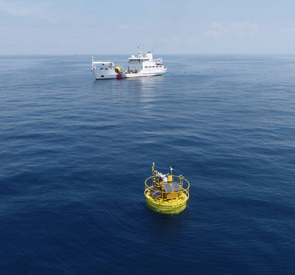
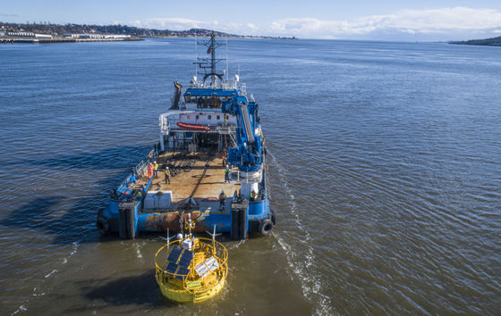
OWA Road map Stage 2 Verification (Dundee, Scotland) |
BA-FLS-NX5, ZX 300M x 1; Windcube offshore V2 x1
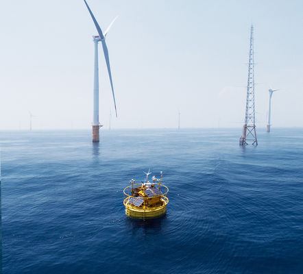
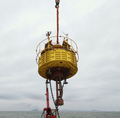
|
Offshore Met Mast Inch Cape
|
Oldbaum Services from the UK (3rd-party certifier ). The final report will be reviewed by DNV |
2023.3 - 2023.9 |
Stage 2 Assessment Report for Windcube: Duration: 6 months; System availability: 100% Data availability: >98.77% for all measurement heights Data accuracy(Wind speed): >2m/s: R2 > 0.995, Slope: 0.990~0.991 4~16m/s: R2 > 0.985, Slope: 0.995~1.000 Data accuracy(Wind Direction): 91m: R2 >0.999, Slope: 1.003, 101m:R2 >0.999, Slope: 1.003, 111m:R2 >0.998, Slope: 1.003 Stage 2 Assessment Report for ZX300M: Duration: 6Months; System availability: 100% Data availability: >96.3% for all measurement heights Data accuracy(Wind speed): >2m/s: R2 > 0.989, Slope: 0.988~0.992 4~16m/s: R2 > 0.981, Slope: 0.988~0.991 Data accuracy(Wind Direction): 91m: R2 >0.992, Slope: 1.002, 101m:R2 >0.991, Slope: 1.003, 111m:R2 >0.987, Slope: 1.003 |
China Three Gorges |
Yangjiang, Guangdong |
BA-FLS-NX5, ZX 300M |
Offshore Met Mast |
Blue Aspirations |
2021 |
Duration: 2 months; System availability:100% Data availability: >99.98% for all measurement heights Data accuracy(Wind speed): >2m/s: R2 > 0.9959, Slope: 0.9964~1.0096 4~16m/s: R2 > 0.9921, Slope: 0.9986~1.0122 Data accuracy(Wind Direction): 50m:R2 >0.9987, Slope: 1.0125, Offset:-1.9075 100m:R2 >0.9986, Slope: 1.0198, Offset:-1.4955 |
China Three Gorges |
Yangjiang, Guangdong |
BA-FLS-NX5, Molas B300M |
Offshore Met Mast |
Shanghai Institute |
2022 |
Duration: 2 months; System availability:100% Data availability: >98.5% for all measurement heights Data accuracy(Wind speed): >2m/s: R2 > 0.99, Slope: 1.00~1.01 4~16m/s: R2 > 0.99, Slope: 1.00~1.02 Data accuracy(Wind Direction): R2 > 0.97, Slope: 1.03, Offset: -1.3 |
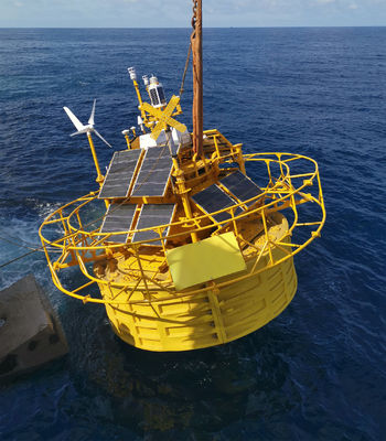
Blue Aspirations |
Prototype validation, Zhoushan, nearshore |
BA-FLS-2.4, ZX 300M |
Fixed ZX 300M |
DNV GL | 2019 |
Duration: 1 month; System availability: 100% Data availability: >97% for all measurement heights Data accuracy(Wind speed): >2m/s: R2 > 0.994, Slope: 0.994~1.003 Data accuracy(Wind Direction): R2 > 0.999, Slope: 0.998-1.002, Offset: -0.83~0.04 |
Huarun |
Cangnan, Zhejiang |
BA-FLS-NX5, ZX 300M |
Offshore Met Mast |
Huarun | 2020 |
Duration: 1 month; System availability: 100% Data availability: >96.24% for all measurement heights except 120m (Note: 91.31%, several foggy days) Data accuracy(Wind speed): >2m/s : R2 > 0.9918, Slope: 0.9889~1.0283 4~16m/s: R2 > 0.9851, Slope: 0.9851~0.9938 Data accuracy(Wind Direction): R2 > 0.9981, Slope: 0.9826~0.9961, Offset: -0.758~1.4559 |
Shanghai Institute |
Nanhui, Shanghai |
BA-FLS-NX5, ZX 300M |
Fixed platform ZX 300 |
Blue Aspirations |
2020 |
Duration: 2 months; System availability:100% Data availability: >99.7% for all measurement heights Data accuracy(Wind speed, >2m/s and 4~16m/s): R2 > 0.97, Slope: 0.98~1.02 Note: the platform LiDAR has an fatal issue with wind direction, thus Wind direction is not compared |
Power China |
Shantou |
BA4.1S, ZX 300M |
Power China |
2020 |
Duration: 3months; System availability:100% Data availability: >99.0% for all measurement heights |
A. INTRODUCTION
In partnership with nine offshore wind developers, the Carbon Trust launched the Offshore Wind Accelerator (OWA) programme and in early 2014, the OWA released its Floating LiDAR Roadmap for Commercial Acceptance (the “OWA Roadmap”). The OWA Roadmap outlines the requirements floating LiDAR systems must satisfy to belong to one of three distinct stages of maturity:
Stage I: Baseline;
Stage II: Pre-commercial; and
Stage III: Commercial.
The BA FLS currently meets the requirements for Stage I, however, the BA FLS has met the availability requirements required by Stage III for more than 30 campaigns with FLS equipped with double LiDARs.
Stage II and III incorporate high accuracy and availability requirements along with evidence of multiple successful long and short verification campaigns against trusted references. In an effort to provide greater confidence to its clients and partners, Blue Aspirations devised the following strategic roadmap for achieving the OWA Roadmap’s Stage II and Stage III classification.
B. OWA STAGE II AND STAGE III REQUIREMENTS
The OWA Roadmap’s Stage II and Stage III data availability and accuracy requirements are as follows:
Availability
KPI | Definition | Acceptance Criteria | |
Best Practice, Stage3 | Minimun Stage 2, Only | ||
MSA1M | Monthly System Availability | ≥95% | ≥90% |
OSACA | Overall System Availability | ≥97% | ≥95% |
MPDA1M | Monthly Post-processed Data Availability | ≥85% | ≥80% |
OPDACA | Overall Post-processed Data Availability | ≥90% | ≥85% |
Accuracy
KPI | Definition | Acceptance Criteria | |
Best Practice, Stage3 | Minimun Stage 2, Only | ||
Xmws | Wind speed – Slope | 0.98 – 1.02 | 0.97 – 1.03 |
R²mws | Wind speed – Coefficient of Determination | >0.98 | > 0.97 |
Mmwd | Mean Wind Direction – Slope | 0.97 – 1.03 | 0.95 – 1.05 |
OFFmwd | Mean Wind Direction – Offset | < 5° | < 10° |
R²mwd | Wind direction – Coefficient of Determination | > 0.97 | > 0.95 |
The OWA requires all Stage II and Stage III systems to have completed campaigns meeting the following duration and frequency criteria:
# | Stage 2 Requirement Description | Required Months | Number of Required Campaigns |
1 | Validation of the LIDAR performance onshore in a fixed frame of reference | The necessary time to fill all the wind bins | 1 |
2 | Validation of the floating LIDAR performance offshore under dynamic conditions | 6 | 1 |
C. CURRENT STATUS
Blue Aspirations carried out the OWA Stage 2 verification in early March 2023 beside the Inch Cape met mast in Scotland. The system kept a very good health condition even powering dual LiDARs(Windcube V2 offshore version and ZX 300M) simultaneously for more than six months. The basic Stage 2 Type Verification report has been delivered by the UK 3rd-party certifier Oldbaum services.
The period of the assessment is 10-03-2023 to 10-09-2023 (6 months). The Windcube LiDAR’s data availability across all heights is over 98.77%, while the ZX is over 96.31%.
And here are the data results compared with Stage 2 KPIs for both LiDARs.
All the KPIs meet Stage 2 Best Practice criteria.
The final report will be also reviewed by DNV.
D. ROADMAP to STAGE 3
We will not stop at Stage 2, we will go further to the Stage 3. According to the OWA Stage 3 requirements we draw up a plan as follows.
Type Verification, Classification and pre-commercial projects requirements for Stage 3 |
Plan and action |
Stage 2 FL Type Verification |
No.1 of BA-FLS-NX5 compared with Inch Cape met mast for Stage 2 FL Type Verification ( In progress in Scotland). May count as 1 of 3 long trials and may count to Classification trials. |
FL Unit Verificaiton (3 long and 3 short trials) |
Three long trials(May count to Classification trials): 1. No.1 of BA-FLS-NX5 is in progress of Stage 2 with met mast Inch Cape in Scotland 2. No.1 of BA-FLS-NX5 will be compared with No.2 met mast for more than 3 months in the next year( The No.2 met mast will be recommended by 3rd party). 3. No.2 of BA-FLS-NX5 will be compared with No.2 met mast for more than 3 months in the next year. Three short trials: 4. No.3 of BA-FLS-NX5 has been deployed in Jiangsu Province of China and is in progress for the short trial of unit verification. 5. The other 2 short trials will be compared with a fixed platform before 2 specific commercial projects(Pre-validation for one month) or we will deploy 2 of BA-FLS-NX5 directly for the unit verification |
FL offshore Classification (3 long trials) |
All these 3 FL Unit Verification long trials may count to FL offshore Classification trials. |
Early Commercial Project deployment |
5 deployments for more than one year. We have actually more than 30 commercial projects in China and more than 5 projects that the FLS has run more than 1 year with over 95% of data availability. However, we still need to follow the OWA Roadmap to be supervised under a third party to prove it. And we will find DNV,UL or other third party to take the job for the following commercial projects. |